
Categories
Things To Do and Outdoor ActivitiesPublished July 12, 2025
Trail Ridge Road Tour: Your Guide to America's Highest Paved Road in Rocky Mountain National Park

Trail Ridge Road Tour: Your Guide to America's Highest Paved Road in Rocky Mountain National Park
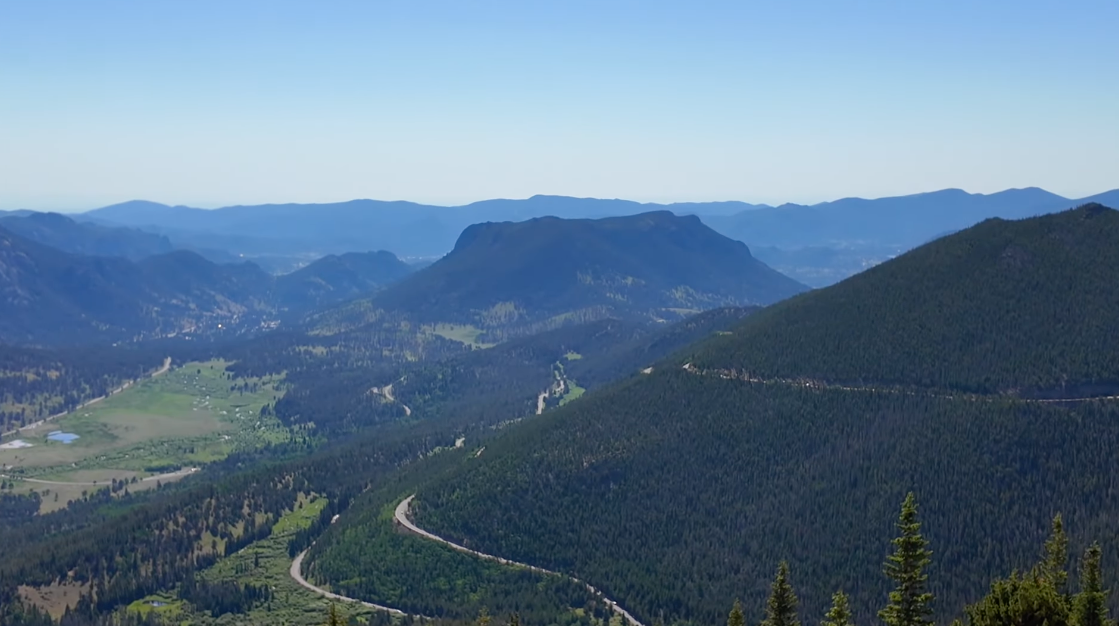
Few drives in America can match the sheer drama of Trail Ridge Road. Stretching 48 miles through Rocky Mountain National Park and connecting Estes Park to Grand Lake, this iconic route climbs to 12,183 feet, making it the highest continuously paved road in the United States. Along the way, you will pass through three distinct ecosystems, witness landscapes shaped by glaciers and volcanoes, and take in views that stretch for miles in every direction.
Whether you are planning your first visit to the Estes Valley or you have driven this road a dozen times, every trip up Trail Ridge reveals something new. This guide walks you through the key stops from Beaver Meadows Visitor Center to the Alpine Visitor Center, with practical tips and local insights to help you make the most of your drive.
Before You Go: Starting at Beaver Meadows Visitor Center
Your Trail Ridge Road journey begins at the Beaver Meadows Visitor Center, your go-to spot for picking up maps, talking to rangers, and getting important updates on weather, wildlife sightings, and road conditions before you head into the park. The visitor center features a large topographical map of the entire park, giving you a bird's-eye view of where you are headed.
Architecture enthusiasts will appreciate that this building was designed by Taliesin Associated Architects, the firm founded by Frank Lloyd Wright. Look for the signature low-profile lines and natural materials that blend the structure into the surrounding landscape. The visitor center was designated a National Historic Landmark in 2001.
Practical Tips Before You Drive:
Check your tire pressure and fuel up in town before you enter the park. There are no gas stations once you start climbing. If you are visiting during the summer season, the park uses a timed entry reservation system. Arriving before the timed entry window kicks in can save you time, but if you plan to arrive later in the morning, make sure you have a reservation in advance through Recreation.gov. Have your park pass and ID ready as you approach the entrance station to keep things moving for everyone.
Three Ecosystems in One Drive
One of the most remarkable things about Trail Ridge Road is how quickly the landscape transforms around you. In just a few miles, you travel through three distinct ecosystems, each with its own character, wildlife, and plant life.
Montane (Up to approximately 9,500 feet): This is where your drive begins. Expect big open meadows, towering ponderosa pines, and abundant wildlife, especially elk during the fall and winter months. The Estes Valley sits within this zone, and the landscape here feels spacious and inviting.
Subalpine (Approximately 9,500 to 11,500 feet): As you climb, the meadows give way to dense aspen groves and narrow lodgepole pines. You will notice stands of dead trees in this zone, evidence of beetle kill pine that has affected forests throughout the region. In spring and early summer, snowmelt creates small waterfalls and fills roadside ditches with wildflowers.
Alpine Tundra (Above 11,500 feet): Above treeline, the world opens up dramatically. This fragile ecosystem supports only the hardiest plants, some of which have survived for hundreds of years despite a growing season of just 40 days. The grasses stay low, the flowers hug the ground, and the wind shapes everything. If you hike in this area, please stay on marked trails. Even a few footsteps off the path can damage the tundra for up to a thousand years.
As you gain elevation, expect the temperature to drop 3 to 5 degrees for every thousand feet of elevation gain. Even on warm summer days, layers are essential if you plan to get out at the higher stops.
Stop by Stop: What to See Along Trail Ridge Road
Hidden Valley
Just off Trail Ridge Road, Hidden Valley is a spot with a rich history and year-round appeal. From 1955 until 1991, this was a popular family ski area with lifts, a lodge, and slopes for all skill levels. Many Estes Park locals learned to ski right here. Today, Hidden Valley is the only place in the park where sledding is allowed during snowy winter weekends. In summer, it transforms into a peaceful picnic spot and easy hiking destination. Backcountry skiers also visit in winter to earn their turns in fresh powder. In the fall, the aspen trees here light up in brilliant yellow across the hillsides, making it one of the best leaf-peeping spots in the park. Hidden Valley is also home to the Junior Ranger Station, so if you have young adventurers in the family, this is a great place to get them started on the Junior Ranger program.
Many Parks Curve
Named for the multiple open valleys visible from this single overlook, Many Parks Curve offers views of Horseshoe Park, Moraine Park, Beaver Meadows, and the upper Estes Valley. These meadows were all carved by glaciers thousands of years ago, and as the glaciers melted, they left behind piles of rocks called moraines. Elk love to graze in the meadows below, and if you visit in the fall, you may hear them bugling. Early morning or just before sunset brings spectacular light across these meadows, making this overlook an ideal spot for photography.
Two Miles Above Sea Level
Between Many Parks Curve and Rainbow Curve, a roadside marker indicates that you have reached two miles above sea level, twice the elevation of Denver. At this point, you may start to notice the thinner air. If you step out of the car, take it easy, especially if you arrived recently from lower elevations. Drink plenty of water and give your body time to adjust.
Rainbow Curve
From Rainbow Curve, you get a sweeping view down into Horseshoe Park, spread out like a wide fan below. This overlook also offers a powerful geology lesson. On one side, you can see the Alluvial Fan, created in 1982 when the Lawn Lake Dam failed and sent approximately 30 million cubic feet of water roaring down the Roaring River canyon. The flood ripped out trees, rolled boulders the size of SUVs, and deposited a massive field of rock and debris. Today, you can hike to the Alluvial Fan and see the evidence of how powerful water can be in these mountains. Rainbow Curve is also where many visitors start to feel the effects of altitude. Take it slow, drink water, and use the restrooms available here before continuing up.
Forest Canyon Overlook
Forest Canyon Overlook is one of the most stunning stops along Trail Ridge Road. This vast U-shaped valley was carved by glaciers thousands of years ago, and from this vantage point you can look down into Forest Canyon with the Big Thompson River winding through it far below. This is a great place to spot wildlife. Pikas squeak from the rocks, marmots sun themselves on the boulders, and you might catch a glimpse of a Clark's nutcracker stashing seeds. If you stand here quietly, you may hear pikas calling to each other like tiny squeaky toys hidden among the rocks.
Be prepared for wind at this stop. Early visitors called it Windy Corner for good reason. You are standing along the Continental Divide where storms love to gather before spilling east. From here, you also get an excellent view of Longs Peak creating its own weather patterns, with clouds forming over the summit on most summer afternoons. If you are above treeline and clouds start rolling in, stay alert for thunderstorms. Lightning strikes at this elevation can be dangerous.
Rock Cut
Rock Cut is one of the most impressive stops on Trail Ridge Road. The name comes from the section of highway that was blasted through solid rock when the road was built in the 1930s. At over 12,000 feet, you are standing in the alpine tundra, so high that trees simply cannot survive. Looking west across the canyon, you will see the Never Summer Mountains. Scan down into the canyon and you may spot Forest Lake and the headwaters of the Big Thompson River, glacial tarns formed when ancient ice carved out the rock basins.
Across the road from the parking area, the Tundra Communities Trail offers a short but steep walk that showcases how alpine plants have adapted to survive at this elevation. Some of the tiny cushion plants along this trail have been growing for hundreds of years. This is also a fantastic spot for wildlife, with pikas darting between the rocks, marmots lounging in the sun, elk crossing the tundra, and occasionally bighorn sheep. Bring a jacket. It is often windy enough here to feel like a wind tunnel, and thunderstorms can blow in fast with nowhere to take cover above treeline.
Snow Fields
As you leave Rock Cut, watch for snow fields along the road, even in late July. These lingering patches of snow are a favorite stop for visitors, and occasionally you get to witness someone experiencing snow for the very first time.
Lava Cliffs Overlook
Lava Cliffs is one of the most geologically unique spots along Trail Ridge Road. The dark rock face here is actually hardened lava from volcanic eruptions that occurred approximately 28 million years ago. This lava poured out of volcanoes in the Never Summer Mountains and cooled into the rugged wall you see today. Later, glaciers scraped over the surface, exposing and polishing the rock. Even in summer, snow and ice cling to the base of these cliffs, among the last patches to melt each year.
Gore Range Overlook
The Gore Range Overlook offers sweeping views of the Gore Range stretching south toward Vail, along with the Never Summer Mountains closer to the road. The Never Summer range is unique because it contains some of the only volcanic mountains in this part of Colorado, and the name fits: snow can linger on those peaks year-round. On clear days, you can see all the way into North Park, the high valley beyond the divide. For geology enthusiasts, the Gore Range is made mostly of ancient Precambrian granite, some of the oldest exposed rock in North America.
Alpine Visitor Center
Your destination at the top of Trail Ridge Road, the Alpine Visitor Center sits at 11,796 feet, making it the highest visitor center in the entire National Park System. Inside you will find exhibits explaining how Trail Ridge Road was built and how life survives at this extreme elevation. A panoramic deck offers views across dozens of high peaks. In summer, rangers offer guided talks and short programs outside. The cafe serves snacks and warm drinks, and a gift shop offers souvenirs from your mountain adventure.
If you are feeling adventurous, the Alpine Ridge Trail (locals call it Huffers Hill) climbs even higher from here. Even fit hikers will feel the altitude, so take it slowly, but the views are worth every step. Keep in mind that the Alpine Visitor Center typically opens from late May through mid-October due to heavy winter snow, and this is the last set of restrooms before you head back down the mountain.
Practical Tips for Driving Trail Ridge Road
Timing: Trail Ridge Road typically opens in late May and closes in mid-October, depending on weather and snowpack. Plows can take weeks to clear drifts that reach 20 feet deep. Check the recorded road status line at (970) 586-1222 before your visit.
Timed Entry: During the summer season, Rocky Mountain National Park requires timed entry reservations. Plan ahead and secure your reservation through Recreation.gov.
Fuel and Supplies: Fill up your gas tank in Estes Park before entering the park. There are no fuel stations along Trail Ridge Road.
Altitude Awareness: The road climbs to over 12,000 feet. Drink plenty of water, take breaks at the overlooks, and watch for signs of altitude sickness, especially if you have recently arrived from lower elevations.
Layers: Expect the temperature to drop significantly as you gain elevation. Bring warm layers and a windproof jacket, even on summer days.
Road Markers: You may notice poles along the road at higher elevations. These guide snowplow drivers in spring so they can find the road edges beneath deep snow.
Wildlife: Keep a safe distance from all wildlife. Elk, marmots, pikas, and bighorn sheep are commonly spotted along the route.
Take Your Time: There is no rush when you are in the mountains. Stop at the overlooks, take in the views, and remember that things happen on mountain time up here.
Frequently Asked Questions About Trail Ridge Road
How high does Trail Ridge Road go?
Trail Ridge Road reaches a maximum elevation of 12,183 feet, making it the highest continuously paved road in the United States. For over 11 miles, the road stays above 11,000 feet.
When is Trail Ridge Road open?
Trail Ridge Road typically opens in late May and closes in mid-October, though exact dates depend on weather and snowpack each year. Call (970) 586-1222 for the recorded road status.
Do I need a reservation to drive Trail Ridge Road?
Yes. During the summer season, Rocky Mountain National Park uses a timed entry reservation system. Reservations are available through Recreation.gov. You can also enter before the timed entry window begins if you arrive early enough.
How long does it take to drive Trail Ridge Road?
The 48-mile drive from Estes Park to Grand Lake takes approximately two hours without stops. However, with overlook stops and short hikes along the way, plan for at least three to four hours for a fulfilling experience.
What should I bring when driving Trail Ridge Road?
Bring warm layers (even in summer), a windproof jacket, plenty of water, sunscreen, and snacks. Fuel up before you enter the park. Binoculars are helpful for wildlife viewing, and a camera is essential for capturing the views.
Is Trail Ridge Road safe to drive?
Trail Ridge Road is a well-maintained paved road, though it reaches extreme elevations with limited guardrails in some sections. Drive at a comfortable pace, use pullouts for slower vehicles, and be aware that weather can change rapidly at high altitude.
Can I see wildlife on Trail Ridge Road?
Yes. Elk, mule deer, marmots, pikas, and bighorn sheep are commonly spotted along the route. In the fall, elk bugling in the lower meadows is a memorable experience. At higher elevations, look for pikas and marmots among the rocks.
What is the Alluvial Fan at Rainbow Curve?
The Alluvial Fan was created in 1982 when the Lawn Lake Dam failed, sending approximately 30 million cubic feet of water down the Roaring River canyon. The flood deposited a massive field of boulders and debris that is still visible today and accessible by trail.
Experience Trail Ridge Road for Yourself
Trail Ridge Road is one of those experiences that stays with you long after you head back down the mountain. From the architectural history at Beaver Meadows to the raw alpine beauty at Rock Cut and the Alpine Visitor Center, this drive captures what makes living in and visiting the Estes Valley so special.
If this drive has you thinking about what it would be like to call this corner of Colorado home, we understand the feeling. At Signature Home Team, we specialize in helping people navigate the Estes Park and Northern Colorado mountain real estate market with local expertise and five-star service. Whether you are considering a full-time move, a second home, or simply want to learn more about mountain living, we would welcome the chance to be your resource.
Relevant Links
Rocky Mountain National Park (NPS): www.nps.gov/romo
Trail Ridge Road Information (NPS): Trail Ridge Road
RMNP Timed Entry Reservations: Recreation.gov
Trail Ridge Road Status: (970) 586-1222
YouTube Channel: Estes Park Living
Join the Everything Estes Park Facebook Group and stay up to date on everything going on in town!
Instagram: @signaturehometeam
Facebook: Signature Home Team
About the Author: Jeff Abel is a licensed real estate agent with Signature Home Team, brokered by Keller Williams Top of the Rockies, specializing in Estes Park and Northern Colorado mountain communities. He shares insights about real estate and mountain living through the Estes Park Living channel.
|


or another way